
Health, Safety and Environment
Western Port Environment
The Port of Hastings lies within Western Port, an area that offers significant environmental values that are recognised worldwide.
Western Port is within a listed Ramsar site, part of an Urban Biosphere Reserve and contains three Marine National Parks and five Special Management Areas. It covers an area of 680sq kms and includes two islands, French Island and Phillip Island, which lie at the centre and entrance of the bay respectively.
Natural Environment
Approximately 40 per cent of the Western Port total area is exposed as mud flats at low tide. Freshwater inflow comes via 17 waterways which drain the catchment. The Bunyip, Bass and Lang Lang rivers are the major inflow points which together contribute approximately 75 per cent of the freshwater inflow. The tidal range (up to 3 metres) within the bay provides a wide variety of marine habitats ranging from deep channels to very extensive sea grass flats, fringing mangroves and saltmarsh and wide tidal mudflats. This variety of marine habitats provides ideal homes for many different species of animals, birds, sponges and corals.
The net water flow in Western Port is primarily in a clockwise direction around French Island. The majority of water exchange with Bass Strait is through the western entrance. Water exchange through the eastern entrance is significantly less mainly due to the greater width of the western entrance.
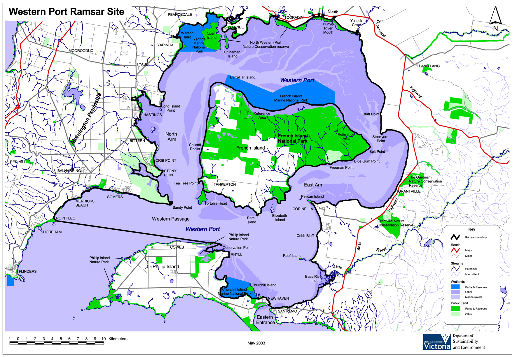
Western Port Ramsar site
(*The Ramsar Convention is an intergovernmental treaty that provides the framework for national action and international cooperation for the conservation and wise use of wetlands and their resources).
The Western Port Ramsar site is one of the 1675 wetland sites around the world which cover 150 million hectares that have been designated for inclusion in the Ramsar List of Wetlands of International Importance. The site comprises four marine and coastal wetland types recognised under the classification system used by the Ramsar Convention*.
These are:
• Marine sub-tidal aquatic beds;
• Intertidal mud and sand flats;
• Intertidal marshes (including saltmarsh); and,
• Intertidal forested wetlands (including mangroves).
Click image to enlarge
Mornington Peninsula and Western Port
Biosphere Reserve
Western Port forms part of the Mornington Peninsula and Western Port (MPWP) Biosphere Reserve which is part of the world network of biosphere reserves recognised by the United Nations Education, Scientific and Cultural Organisation (UNESCO) through its Man and the Biosphere Program.
Biosphere reserves are areas significant on a world scale for their characteristic landforms, plants and animals, and the way they have been used by people. The local administration authority for the Biosphere Reserve is the Mornington Peninsula and Western Port Biosphere Reserve Foundation.
(*The Man and the Biosphere (MAB) Programme is an Intergovernmental Scientific Programme aiming to set a scientific basis for the improvement of the relationships between people and their environment globally).
You are now leaving the Port of Hastings website. The website you are entering is not maintained or funded by the State of Victoria. Please follow the link to continue to the Mornington Peninsula and Western Port (MPWP) Biosphere Reserve website. This page will automatically redirect you.
Mornington Peninsula and Western Port (MPWP) Biosphere Reserve
Marine National Parks
The Marine National Parks and Sanctuaries within Western Port are part of a network that was established in 2001.
These highly valued and protected areas are part of a state-wide system representing the range of marine environments in Victoria. In these areas, no fishing, extractive or damaging activities are permitted.
The Western Port Marine National Parks include:
• Yaringa Marine National Park
• French Island Marine National Park
• Churchill Island Marine National Park.
Special Management Areas include:
• Honeysuckle Reef
• Crawfish Rock
• Bass River Delta
• San Remo
• Rhyll.